


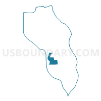
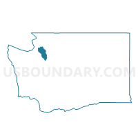
Lagoon Point Voting District, Island County, Washington
About
Outline

Summary
| Unique Area Identifier | 684484 |
| Name | Lagoon Point Voting District |
| County | Island County |
| State | Washington |
| Area (square miles) | 10.86 |
| Land Area (square miles) | 7.51 |
| Water Area (square miles) | 3.36 |
| % of Land Area | 69.09 |
| % of Water Area | 30.91 |
| Latitude of the Internal Point | 48.05066570 |
| Longtitude of the Internal Point | -122.57670900 |
Maps

Graphs
Select a template below for downloading or customizing gragh for Lagoon Point Voting District, Island County, Washington


Neighbors
Neighoring Voting District (by Name) Neighboring Voting District on the Map
- Bush Point 1 Voting District, Island County, WA
- Bush Point 2 Voting District, Island County, WA
- Greenbank Voting District, Island County, WA
- Water: Admiralty Bay, Island County, WA
- Water: Holmes Harbor, Island County, WA
Top 10 Neighboring County Subdivision (by Population) Neighboring County Subdivision on the Map
- South Whidbey Island CCD, Island County, WA (13,630)
- Central Whidbey Island CCD, Island County, WA (12,458)